In our last article, we saw the Seine at its most pleasurable. This week, we take a look at the river’s more tumultuous and even dangerous side. It might be easy to imagine that the Seine flows peacefully along day in and day out, year in and year out. Not so. The river possesses a history of severe flooding which devastated the city and the population over and over again throughout the centuries.

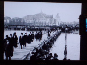
Flooding in 1910 forced the construction of temporary wooden sidewalks in front of Les Invalides
Between the 6th and 20th centuries, Paris and the Seine basin experienced no fewer than 65 severe floods. How did the city measure the deluges? The oldest benchmark is located on the Pont de la Tournelle in the 5th arrondissement where the level 0 corresponds to the lowest level of the Seine in 1719. Here is a list of the most disastrous overflows of the Seine and how many meters the waters rose during those times:
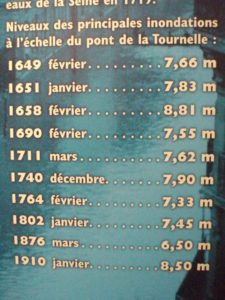
The last large flood occurred in 1910 when the Seine overflowed its banks by 8.5 meters, or by more than 20 feet. During the late 1800’s, engineers in Paris put in place the Paris sewer system as well as a distribution system for drinking water. They also installed a network of drains and surveillance mechanisms in anticipation of future floods of the Seine. However, they only planned for inundations reaching the level of the last big flood of 1876 which topped off at 6.5 meters.
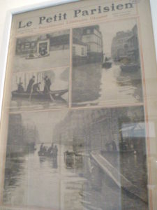
It wasn’t long before the French engineers’ efforts were put to the test. The summer of 1909 was particularly rainy in the Paris region. To make things worse, the following winter saw heavy rain and snow which saturated the soil and caused the Seine to surge upstream. Then, on January 18, 1910, torrential rains began falling all over Europe. Word of the Seine’s rising waters started to appear in the newspapers. Most Parisians shrugged off the overflow as typical of the winter season. But there were signs that it was not the winter river as usual. The waters of the Seine were moving much faster than normal. River traffic disappeared since navigating the Seine was close to impossible. Then debris of all sorts including large trees, wooden boards, beams, barrels and more came rushing downstream destroying bridge supports and anchored boats in their way.
By January 22, the saturated earth and runoff from city streets meant that the water started flooding the city from below. Paris basements filled with water which came through drainpipes and even seeped through cellar walls. Manholes and sewer grates turned into fountains as waters surged up from underground. In addition, many Métro stations filled with water and had to be closed. The Gare d’Orsay’s electric train tracks were completed submerged. Streets became rivers themselves and squares turned into small lakes. Of course, some water overflowed the Seine’s banks itself but it is ironic to note that a good part of the flooding came from below ground. By January 26, boats were necessary to get around the capital. According to author Jeffrey Jackson who wrote Paris Under Water, a detailed account of the Paris flood of 1910, “northern France had experienced the ‘perfect storm’ of events that led to the drowning not just of Paris, but of the entire region.”
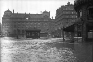
The Gare St. Lazare neighborhood had turned into a lake
Paris was a complete diaster. Not only did the flooding make normal life close to impossible with transport, communication, power and food supply issues, but also the receding waters brought in a host of new problems including filth, rotting floors and furniture, disease and more. Fortunately, the City of Paris, the French government, the Catholic Church, the Red Cross, responsible citizens and others came together to get through the calamitous event.
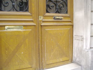
Today, you can still see markers where the flood waters reached in various corners of Paris. For years, I passed by this beautiful doorway near the Musée d’Orsay without really paying attention to it. Crue in French is another word for ‘flood’ or inondation. Here are some passersby who have stopped to look and take photos of these flood reminders.


While San Marco’s Square in Venice regularly floods to this day, Paris thankfully is spared that kind of disruption. In the years that followed the 1910 flood up until today, engineers have rethought the city’s foundations and hopefully prepared for future inondations de la Seine. Since then no floods like the one of 1910 have occurred again; however, the City of Paris still has to close lower river quays from time to time when the waters rise slightly in the winter.
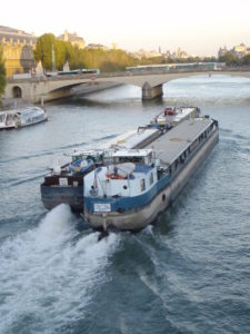
The next time you’re in Paris, take a few pics of this pretty French waterway, enjoy a ride on the Bateaux Mouches, use the Batobus water transport (thank you to French Affaires’ reader Jane who wrote in to say that she and her husband skip the Metro in favor of this easy city navigation route!), and keep your eyes open for markers of the great flood. It’s a piece of Paris history worth knowing about.
French Take-Out ~ La France à emporter
If you are interested in more history on the most recent Paris flood, you might want to pick up a copy of Paris Under Water: How the City of Light Survived the Great Flood of 1910 by Jeffrey H. Jackson. It’s a fairly short read at about 220 pages (you might want to skip the philosophizing epilogue which doesn’t add much to the historical account). You’ll never think about Paris and the Seine the same way again!
